Enter, find and use location coordinates on Google Earth

Google Earth is a useful program to work on architectural projects, infrastructure engineering, and urbanism but also to simply locate yourself in a city, as it offers an accurate GPS system. To use this feature, you must enter the geographic coordinates, including the longitude, latitude, and compass points. Read this article to see how to enter your geographic coordinates on Google Earth, how to change their format and find coordinates for a specific location.
How to find coordinates for a location
Coordinates will be displayed in the lower right corner of the Google Earth page as you move the mouse over the map.
How to use coordinates to search for a location on Google Earth
To find a place on Earth based on its geographic location, simply open Google Earth and paste the coordinates in the search field. You can use these formats:
- Decimal Degrees: such as
37.7°, -122.2° - Degrees, Minutes, Seconds: such as
37°25'19.07"N, 122°05'06.24"W
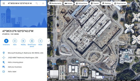
For example, you can try it with Microsoft headquarters GPS coordinates: 47°38'20.98" N 122°07'42.01" W and Google Earth will point to its exact location.

How to choose how coordinates display
You can change the format of location coordinates if you wish. There are 4 formats available:
- Decimal Degrees: such as
37.7°, -122.2° - Degrees, Minutes, Seconds: such as
37°25'19.07"N, 122°05'06.24"W - Degrees, Decimal Minutes: such as
32° 18.385' N 122° 36.875' W - Universal Transverse Mercator: such as
10 S 055974, 4282182
Here's how to change how location coordinates display on Google Earth
On a Windows/Linux computer:
- Open Google Earth and click Tools > Options.
- Select 3D View. Next, select a display format that you prefer under Show Lat/Long.
- Click OK.
- Open Google Earth and click on the menu icon (three horizontal lines).
- Select Settings and scroll down to Formats and Units.
- Choose the format you like next to Latitude/Longitude formatting tab.

